
Snipers Point
The Unclaimed Point.
Published 9-13-2020 | Last updated 9-13-2020
60.908, -149.409
| History | Local name reported in 1899 by Lieutenant Herron (1901, map facing p.11), USA. |
|---|---|
| Description | On the N end of the Kenai Peninsula, on the S side of Turnagain Arm near the mouth of Sixmile Creek, 1 mi NE of Sunrise, Chugach Mts. |
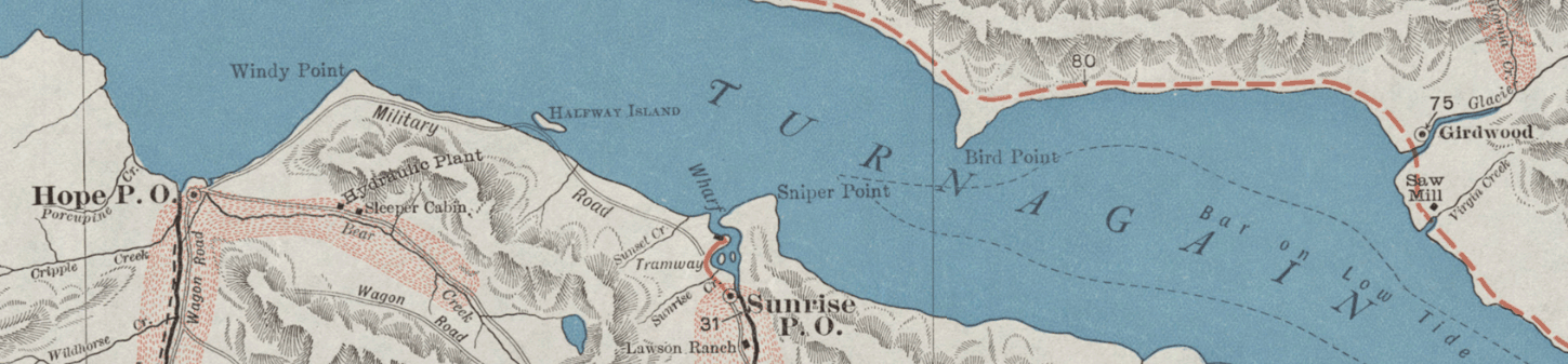
Certain names have a way of grabbing attention and rousing curiosity. Snipers Point, situated on the south shore of Turnagain Arm nearly opposite Bird Point, is good at catching the eye of those looking at a map of the Anchorage area. It’s an old name, notably appearing on D.H. Sleem’s 1910 map[1] close to a tantalizingly labeled ‘military road.’ The U.S. Federal government had their crosshairs on it even earlier, when Lieutenant Joseph Herron passed through the area in 1899.
But in this case the sniping is not a reference to sharpshooting. The military road was labeled that way because its construction was overseen by the U.S. Army.[2] No military garrisons were located nearby and Sunrise City and Hope City were self-administered through citizens’ and miners’ meetings and considered themselves “strict and straight and just.”[3]. There were a few shootings, as in most frontier towns, and a bridge blown up with stolen dynamite, but those are unrelated stories for another day.
Although the terms ‘to snipe’ and ‘sniper’ have been associated with firearms and marksmanship in English since the late 1700s,[4] the words had a different meaning in the jargon of miners and prospectors. ‘Sniping’ refers to the general practice of working unclaimed land, which could entail picking over abandoned claims or working ground too marginal to have ever been staked. The term was confirmed to be in use in the Cook Inlet gold camps at the time: in August 1896, professional miner Frank E. Howard noted eighty-seven claims being worked in the Sunrise Mining District, not including "the 'snipers' who are working upon exposed pieces of bedrock."[5]
At a time when a recording fee to file a claim was $2.00,[6] or roughly equal to a laborer’s daily wages,[7] sniping was a way to make a quick buck without having to locate a claim and pay the filing fees. Sniping marginal public ground may even have been the only option for latecomers to Hope and Sunrise, as by 1896 "the entire district [was] plastered over with claims".[7]
In the spring of 1899, a location everyone considered marginal seems to have revealed some paydirt. On April 19, John Lindeback staked the Kronoby Claim (likely named for a village in Finland) along the shoreline. His claim does not reference Snipers Point, but two days later J.H. Brownlow staked the Everett Quartz Lode Claim, “situated on Snipers Point and joins the Kronoby Quartz Lode Claim”.[8]
It seems unlikely that a name would be referenced without explanation if it had been invented in the preceding two days. The most plausible scenario is that it was an established local name prior to 1899, and that Snipers Point was known to have gold in quantities too small for anyone to bother claiming but large enough for snipers to reliably earn some cash. In a town obsessed with strikes and bonanzas, a place known exactly for its lack of gold for would hardly have been written about until the strikes in April 1899 propelled it into the limelight.
A few weeks later Herron began his reconnaissance of the region lasting from May 13th to May 30th, and around the time he arrived at Portage Bay the Seattle Post-Intelligencer published news of the strike, misspelling the location 'Sneiper’s Point.'[9] Herron's original sketch map, the one referenced in the GNIS entry, could not be referenced due to a strange editorial choice by Kessinger Legacy Reprints to print the page in its folded-up state.[10] The Choss Lore project could not locate a copy of the sketch map in any of several digitized versions of the report which are available online.
“Some wander up the creeks in search of gold,
They call it sniping as I was told,
From worked out claims, deserted I suppose,
The sniper still finds gold, and silently he goes.”
-Excerpt, The Beach Miner and the Sniper, Nome Daily Nugget, 1935.[11]
Sources
[6] Mills, S.J. Minutes of Miners Meeting, July 27, 1895. Sunrise Mining District Mining Book 7, 14.